Quick Links
Public transit is intimidating. Working out the schedules, stops, and the rest can feel like a big job, especially if you're new to a city or just visiting for a week. But catching a ride doesn't have to be complicated. With the right apps, you can look up directions, work out connections, and know when the next bus is coming, all at a glance.
When it comes to catching a ride, anywhere, the first app you need is Google Maps. It doesn't have a lot of transit-specific features, but it is by far the most universal app out there in terms of transit data, as this massive list of supported cities outlines.
In my opinion, however, Google Maps isn't enough. When you're standing at a bus or train stop, you're going to want to know when the next bus is coming, and Google Maps doesn't offer that at a glance. This is why I recommend you download an application specifically for arrival times. There are three main apps for this:
- Transit App, which works in these cities.
- Moovit, which works in these cities.
- Citymapper, which works in these cities.
These apps are different in many ways, but all serve the same basic function: location-aware, at-a-glance-schedules. I personally use Transit App, but am listing all three here so readers can find something that works in their area.
With that in mind, here are some useful things you can do with the transit apps at your disposal.
Get Directions, Complete With Connections
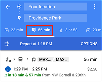
If you want to get somewhere by transit, the simplest way to start is usually Google Maps. Simply type where you want to go, and your starting point if necessary, then pick the transit option:
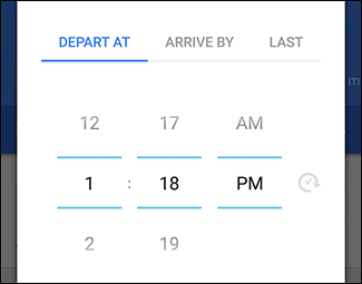
You'll get see a few options, as shown above, and can optionally choose a departure and/or arrival time. This is essential for planning trips in advance.
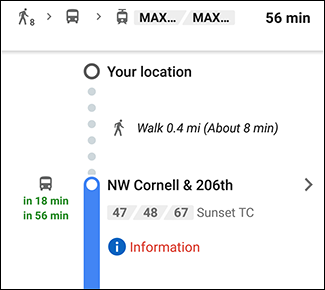
Set everything up and you'll be told where you need to go, when, and you can even get real-time instructions. With this you'll never feel lost.
If you want your phone to hold your hand as you use public transit for the first time, it's as easy as that. But there's one potentially stressful thing to worry about: late buses.
Always Know When the Next Bus Is Coming
Google told you where the bus stop is, and you found it, but the bus isn't here yet. Should you panic?
Don't panic. Open whichever app you installed for at-a-glance arrival times.
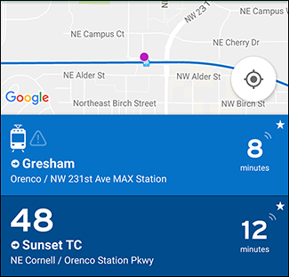
I use Transit App here in Portland, so I'll outline that here. This application detects your current location, then automatically shows you how many minutes until the next bus or train for all lines near you.
If you see little waves above the countdown clock, as seen above, the countdown is being updated in real-time, using data from your local public transit agency. This is an absolute godsend if a bus or train is late, because you can quickly find out that you're not crazy and/or a person who missed the bus.
Note that the default listing might be your line headed in the wrong direction. Simply swipe to reverse that.
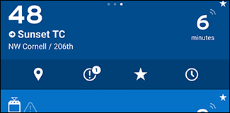
You can also tap any line to see a row of icons.
From left, these small icons give you:
- The location of the stop, and a map of the route.
- Alerts and other notifications about the route.
- The ability to favorite a given route. Favorites always show up at the top of your list when you open the app, making this option useful if you ride a few routes regularly.
- Complete schedule for the current route.
The features, together, make waiting for transit a lot less stressful.
Bonus: Buy Tickets With Your Phone
With Google Maps for directions, and Transit App for real-time schedules, using public transit is simple. And, depending on where you live, your phone can become even more useful. Many transit agencies offer official apps that allow you to buy tickets on your phone, which makes getting onto the bus or train a lot faster.
Sadly, the official app for this is going to vary depending on your specific region or city, and not every area offers this. I recommend checking the official website for your local transit authority; they will likely link to such an app there, if it exists.
Photo credit: IQRemix

